DRONE THERMAL IMAGING SERVICES
Our drone thermal imaging surveys transform aerial data into powerful insights that save time and money for our clients.
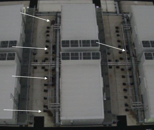
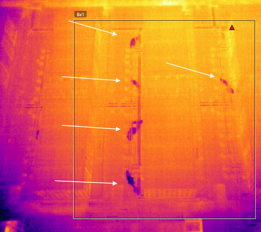
A thermal imaging camera is securely fixed to one of our commercial drones. Using the unique aerial perspective that drones provide, we can access areas safer and quicker than a handheld inspection. The camera accurately measures levels of infrared radiation across multiple areas of interest. This data is then processed to produce a thermal image which can be very precisely quantified or measured.
- Facilities management teams are finding water ingress, roof degradation, weather damage, and low quality installation.
- Oil & Gas customers are revealing underground pipelines, leaks, and hotspots.
- Solar customers are detecting string outages, faulty modules, and even sub-module defects over hundreds of MW.
The Zenmuse XT2 by FLIR. It has a dual camera that allows us to capture both 4K visual and thermal imagery. This is useful as it allows our customers to see a side-by-side comparison of the problematic area, giving a better understanding as to what might be causing a hot or cold spot.
Yes, we provide a full report detailing every anomaly found. This would include all imagery (both visual and thermal), accompanying notes and conclusions.
Yes, but in our experience, thermal images are more effective. We do offer a visual drone video survey of the structure for use with the report.
Every project is priced individually and the price is dependent on the customers requirements. Contact us below to receive a quote tailored to your needs.